
Object Record
Images
Metadata
Accession Number |
2004.74.00 |
Catalog Number |
2004.74.12 |
Object Name |
Map |
Collection |
Ahmad Ibrahim |
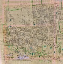
Description |
Hand-drawn map of Jimsu (also spelled Jimzu) Palestine on pasted together grid paper with black and green ink and pencil. Ahmad Ibrahim created this map of his home village which was destroyed in 1948 during the creation of the State of Israel. From memory, he labeled in Arabic the area where each individual neighbor lived with their names. Ahmad Essa Ibrahim was born in Jimsu (also spelled Jimzu,) Palestine in 1922. In 1948, he and his family were forced to leave their home and farmlands following the declaration of the State of Israel. They left behind their wheat mill and groves of fruit and olives and fled to the West Bank, where they lived in a tent near Ramallah. Ibrahim's wife Aisha had a cousin in Brooklyn who agreed to sponsor Ahmad as part of the Refugee Relief Act of 1953. Aisha sold her jewelry to pay for her husband's travel to America in 1956. In 1962, Ahmad returned to his family for 10 months and brought two of his children back to the United States with him. In 1966, the whole family reunited in America. All of Ahmad and Aisha's children went on to receive advanced degrees; four of them became medical doctors. |
Artist |
Ahmad Ibrahim |
People |
Ibrahim, Ahmad |
Search Terms |
Palestine Palestinian Americans |
Subjects |
Maps |
Lexicon category |
8: Communication Artifact |